
Know your Flood Hazard
Bodies of Water
The Tolt and Snoqualmie Rivers experience seasonal flooding in the City of Carnation. The NOAA National Weather Service Northwest River Forecast Center specializes in flood and water resource forecasting, river modeling, and hydrologic system development. Daily flood forecasts are made using observations of temperature and precipitation.
Floodplain Map
Below is a map of Carnation created by the Flood Emergency Management Agency (FEMA)'s Flood Map Service Center. Click the link below to enter an address to create your own flood map.
Click HERE to access the FEMA Flood Map Service Center
Tolt Dam and Other Information
The City of Seattle owns and operates the Tolt Reservoir and Dams, located 16 miles upstream from Carnation on the South Fork Tolt River. The reservoir stores 30% of the drinking water for the metropolitan Seattle area. In the unlikely event of a dam failure, water from the reservoir may inundate the city of Carnation.
The Tolt Dam Early Warning System alerts residents in the city of Carnation to evacuate in the unlikely event of a dam failure. Siren testing for the warning system is conducted at noon every Wednesday. The tests involve activating the sirens and playing pre-recorded messages.
Seattle Public Utilities is working to replace the aging system with state-of-the-art technology and equipment that will improve the resiliency, reliability, and security of the emergency warning system.
Hazard Description
Floods are a natural and inevitable occurrence along the rivers in the City of Carnation, In the Pacific Northwest, winter flooding is dominated by heavy precipitation events, while spring flooding is the result of snowmelt augmented by precipitation.
The Tolt River stream gauge TOLW1, USGS Site 12148500, is located 5.5 miles northeast of Carnation, at river mile 8.7; on the right bank. The drainage area for this gauge is 81.4 mi2. Elevation of the gauge is 348 feet.
The Snoqualmie River stream gauge CRNW1, USGS Site 12149000, is located 1.3 miles northwest of Carnation, 1.9 miles downstream from the Tolt River, at river mile 23.0, on the left bank. The drainage area for this gauge is 603 mi2.
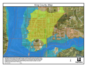
Floodplain Map with Parcels
Below is a map of Carnation created by King County iMap with City parcels.
- Green = FEMA 500-year floodplain
- Light Blue = FEMA 100-year floodplain
- Dark Blue = FEMA floodway
Click the link below to enter an address to create your own map. After you locate your desired area, select "Flooding info" from the layers list.
Click HERE to access King County iMap
Information on Past Floods
Click the link below to access historical information on Significant Washington Floods:
Flooding in Washington (weather.gov)
King County has detailed instructions available on how to view historical flood photos on their interactive web-based mapping system (iMap)
Link to a Local Site that Provides Hazard Information by Address
King County Interactive Map - Flood Information
Note: this link will open a new browser window
Zoom in to your area of interest. In the layers list, click "Flooding info" and the layers you need: FEMA preliminary 500-year or 100-year floodplain, FEMA preliminary floodway, flood photos, river gages or river facilities. Click on point symbols for photos and data.
Insure your Property for your Flood Hazard
Homeowners Insurance Excludes Flood
Standard home insurance policies cover many types of water damage, but the damage caused by floods is not covered.
There are two primary reasons it is necessary to exclude “flood” from a homeowners policy:
- Flood losses are often devastating natural disasters that cause more property losses than any individual insurance company can financially withstand.
- Most surface water losses can be prevented with proper landscaping of a property that drains water away from structures.
National Flood Insurance Program (NFIP) is Available in the Community
In 2022, The City of Carnation received a Community Rating of Class 7 to allow for a 15% automatic discount on all flood insurance policies issued or renewed for properties within the Special Flood Hazard Area (SFHA) within our city limits. Our commitment to keeping Carnation more disaster resistant enhances public safety, protects the natural functions of floodplains, property protection and reduces flood insurance premiums.
30 – Day Waiting Period
To purchase flood insurance, call your insurance company or insurance agent, the same person who sells your home or auto insurance. Plan ahead as there is typically a 30-day waiting period for an NFIP policy to go into effect, unless the coverage is mandated by a federally backed lender or is related to a community flood map change.
Facts of Coverage
In the event of a flood, your National Flood Insurance Program (NFIP) policy covers direct physical losses to your structure and belongings. Purchasing flood insurance will help protect the things you value. The NFIP offers two types of coverage – building coverage and contents coverage – to protect your home and belongings. For more information about what flood insurance covers, click the link below:
Click HERE to visit the FloodSmart website
Rating Information
The Community Rating System (CRS) is a voluntary incentive program that recognizes and encourages community floodplain management practices that exceed the minimum requirements of the National Flood Insurance Program (NFIP).
Click HERE for more CRS Information
Link to FloodSmart NFIP
Click HERE to access the official site of the National Flood Insurance Program
Names of Local Insurance Agents
If you need help finding a provider go to FloodSmart.gov/flood-insurance-provider or call the NFIP at 877-336-2627.
See below for the contact information of local insurance agents:
Hauglie Insurance
33410 SE Redmond-FC RD
Fall City, WA 98024
Kern Rustad Insurance Agency
204 Ballarat Ave. N
North Bend, WA 98045-8215
Allstate Hale Agency
910 NE High ST
Issaquah, WA 98029
Potter Insurance
1495 NW Gilman BLVD, #2
Issaquah, WA 98027
Protecting People from the Flood Hazard
Don’t Drive in Flooded Areas
The King County Road Alert Map shows road closures and conditions. Problems on King County maintained roads can be reported by calling 206-296-8100 or 1-800-KC-ROADS.
Flood Warning Signals
King County helps you stay informed about potential hazards and threats that impact our area. A recorded flood-information hotline is updated hourly: 206-296-8200 or 1-800-945-9263. For help interpreting flood information, call 206-296-4535 or 1-800-768-7932. You can also register your email address or phone number to receive important safety information during an emergency. Sign-up is free.
- Tolt River Flood Warning System
- Snoqualmie River Flood Warning System
- Sign up for King County Flood Alerts
Link to the Emergency Response Plan
The City is currently in the process of updating the Comprehensive Emergency Management Plan (CEMP), which is set to be finalized by Fall 2023. See below for the most up to date version from 2015.
Safety Tips for Buildings
Use sandbags to protect your home from flood waters if you have sufficient time to do so. A supply of sand and sandbags is available at the City's Public Works Maintenance Shop, located at 33100 NE 45th Street. These supplies are limited, and available for self-service on a first-come first-serve basis from 8:00AM to 3:30PM, Monday through Friday, following a declared flood warning announcement. Please bring your own tools to fill sandbags. There is a 50-bag limit per household.
Where to find sandbags in King County and how to use them
Have a professional install check-valves in plumbing to prevent flood waters from backing up into the drains of your home. Make sure your sump pump is working and consider having a backup. Make sure your electric circuit breakers, or fuses, are clearly marked for each area of your home.
Evacuation Routes and Shelters
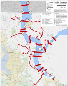
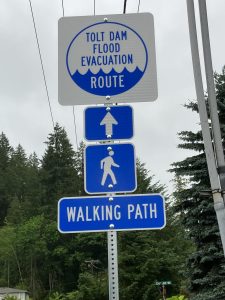
In the event of a catastrophic failure of the Tolt Dam, the City has a 20-acre pedestrian evacuation site in Tolt Highlands. An evacuation trail starts at the east end of NE 50th St, and the other begins on E Entwistle St going up Tolt Highlands Rd. The routes to these trails are marked by pedestrian evacuation signs. The evacuation site is for pedestrian access only, no vehicles. For vehicular evacuation, follow the route signs north on SR 203 to Stillwater Hill Rd.
Sign-up to receive important information from King County Emergency Management about potential hazards that impact the Carnation area, including status updates on the Tolt Dam.
Safety Tips for Evacuation
- Follow the directions of emergency alerts and law enforcement.
- When told to evacuate, do so immediately. If you have mobility concerns call 911. Failure to evacuate creates additional safety risks for yourself and first responders.
- Grab your emergency supply "go" bag and take your family and pets to high ground.
- Once out of the area, stay out until emergency personnel say it's safe to return.
- Never drive or walk through flooded areas. It is the number one cause of flood related deaths. You can be knocked off your feet by as little as six inches of moving water.
Click HERE for more King County Dam Safety Information
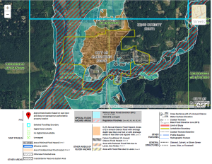
Map of Information on Areas Predicted to Flood
The Tolt River Inundation map (shown on the upper right of this page) shows the places that would be affected in the event of a dam failure. See the Snoqualmie Valley Record article below for more information about flood risk.
If the Tolt River Dam breaks, these places are at risk of flooding | Snoqualmie Valley Record
Protect your Property from the Hazard
Wind/Hurricane Damage
The Puget Sound region experiences strong windstorms, including ones with hurricane force winds known as mid-latitude cyclones. These storms are wider that tropical storms.
- Power outages are the most wide-spread problem caused by windstorms.
- Structural damage is the costliest consequence of windstorms. Much of the damage comes from falling trees. Damage can occur at wind speeds as low as 32 mph and destroy wood frame structures at speeds around 100 mph.
- People have died from falling trees and branches. Because many windstorms happen in winter and many residents are dependent on electricity for heat, cold-related health problems are a hazard. Several people were killed in King County while heating their homes with charcoal fires during the power outages following the 2006 storm.
Click HERE for more information on Seattle windstorms
Importance of Maintaining the Drainage System
Maintaining your property's drainage system is your responsibility.
- Inspect regularly. This is especially important on commercial properties that have catch basins or other drainage systems.
- Ask a professional to inspect your underground drainage system.
- Clear drains in and near your property. If you have sloped driveway, clear the drain at the bottom of the slope.
- If you live at the base of a hill or on a bluff, check that drainage and retaining walls are properly functioning.
- Water causes unstable slopes, mudslides and erosion. Check your property for signs of earth movement, such as leaning trees, or cracks in the soil or sidewalks. If you have a problem, contact a soils engineer (search the Web for "Engineers Geotechnical Soils") to evaluate the situation.
Gutters and downspouts:
- Inspect regularly for leaks or damage.
- Clean at least twice a year.
- Direct downspout flows at least 5 feet away from your foundation, without sending flows to adjacent properties.
- Never discharge water over the edge of a steep hill.
Click HERE for more information on wet weather preparedness from the City of Seattle
Ways to Permanently Retrofit a Building
- BASEMENT INFILL: This involves filling in a basement located below the BFE to grade (ground level). Sections of the basement walls that remain above ground must be retrofitted with flood openings that allow automatic entry and/or exit of floodwaters. Any basement utility systems and associated equipment must be elevated to protect utilities from damage or loss of function from flooding.
- ABANDON LOWEST FLOOR: This approach involves abandoning the lowest floor of a slab-on-grade residential building with more than 1 story. The lowest floor walls must be retrofitted with flood openings that allow automatic entry and exit of floodwaters. Additionally, any utility systems and associated equipment on the lowest floor must be elevated to protect utilities from damage or loss of function from flooding.
- ELEVATE LOWEST INTERIOR FLOOR: This approach involves elevating the lowest interior floor within a residential building. The home must have high ceilings for this approach to work. The space below the lowest elevated interior floor must be either filled to create a stem wall or retrofitted with flood openings that allow automatic entry and/or exit of floodwaters. Additionally, any utility systems and associated equipment located below the lowest interior floor must be elevated to protect utilities from damage or loss of function from flooding.
- WET FLOODPROOFING: Wet floodproofing is a design strategy that includes choosing flood-resistant materials and allowing flood waters to enter the enclosed areas of a house at nearly the same rate at which the water level is rising outside of the house. Wet floodproofing is used for spaces that will be minimally damaged by flood water such as enclosures below elevated buildings, walkout-on-grade basements, below-grade basements, crawlspaces, or attached garages.
Click HERE for more information on how to retrofit a building.
Emergency Flood Proofing Measures
FEMA defines floodproofing as any combination of structural and non-structural additions, changes, or adjustments to structures which reduce or eliminate flood damage to real estate or improved real property, water and sanitary facilities, structures and their contents.
Several methods are available to protect a building from flood damage:
- If you expect floodwaters below 2 feet, you may wish to place an earthen berm around your property.
- You may also consider waterproofing your house or placing watertight closures over the doorways, though this method is not recommended for expected floods over 2 feet or for structures with basements.
- Even houses not expected to be flooded may have sewers that back up into the basement during heavy rains. Installing a plug or a sandpipe purchased from a local hardware store can prevent the back-up when floodwaters are less than 2 feet; valves or other measures may be taken to prevent back-up from larger flood, but please consult a plumber before installation.
How to Report Dumping in the Drainage System
To report drainage concerns in the City of Carnation, please contact Carnation City Hall at (425) 333-4192
FEMA's Retrofit Recommendations
The following FEMA publications offer detailed information on permanent retrofitting measures:
FEMA P-312: Homeowner's Guide to Retrofitting
FEMA P-936: Floodproofing Non-Residential Buildings
FEMA P-259: Engineering Principles and Practices for Retrofitting Flood-Prone Residential Structures
FEMA P-1037 Reducing Flood Risk to Residential Buildings That Cannot Be Elevated
FEMA P-348 Protecting Building Utility Systems From Flood Damage
Locally Pertinent Protection Website
Carnation-Duvall Citizen Corps Council (CDCCC)
Based on potential hazards and the need for assistance for our local professionals, the communities of Carnation and Duvall banded together in 2002, to form a Citizen Corps Council to better protect their 20,000 residents. Along with active Community Emergency Response Teams (CERT), Medical Reserve Corps (MRC) volunteers, Snoqualmie Valley Amateur Radio Club (SnoVARC) and Firewsie the Carnation-Duvall Citizen Corps (CDCCC) and is one of the first Citizen Corps Councils in King County. Their purpose is to make our communities stronger, safer and better prepared.
Build Responsibly
All Floodplain Development Needs a Local Permit
Click HERE to view Carnation's Flood Hazard Development Permit
Permitting in the City of Carnation is handled by the Community Economic Development Department. For questions regarding permits, see the contact information of the CED Manager below:
Beth Offeman
- (425) 550-8157
- beth.offeman@carnationwa.gov
- 4621 Tolt Avenue Carnation, WA 98014
How to report Illegal Floodplain Development
All code enforcement issues are handled by the Community Economic Development Department. To report development concerns in the City of Carnation, contact the CED Manager:
Beth Offeman
- (425) 550-8157
- beth.offeman@carnationwa.gov
- 4621 Tolt Avenue Carnation, WA 98014
Summary of the Rules for New Construction and Substantial Improvement
For all new or substantially improved flood-proofed nonresidential structures where base flood elevation data is provided through the flood insurance study, FIRM, or as required: Obtain and record the elevation (in relation to mean sea level) to which the structure was floodproofed; and maintain the floodproofing certifications required in CMC 15.64.020(B). More information can be found in the Carnation Municipal Code which is linked below.
Substantial Damage Rules
New construction, substantial improvement, and/or reconstruction due to substantial damage of any residential structure shall have the lowest floor, including basement, elevated one foot or more above the base flood elevation. Mechanical equipment and utilities appurtenant to the residential structure shall be elevated at least one foot above the base flood elevation. More information can be found in the Carnation Municipal Code which is linked below.
Link to Relevant Building Code Sections or the Floodplain Management Ordinance
In all areas of special flood hazards, the following standards are required:
A. Anchoring
B. AH Zone Drainage
C. Construction Materials and Methods.
D. Utilities
E. Subdivision Proposals
F. Review of Building Permits
Protect Natural Floodplain Functions
Description of the Habitat, Threats, and Recovery Actions for Threatened and Endangered Species within Range in the Community
The Tolt River is home to Chinook salmon, bull trout, and steelhead trout. These fish species are all listed as threatened under the Endangered Species Act. This project will support their recovery by providing access to critical habitat. The project will reopen a blocked side channel of the river. Fish need side channels to lay eggs, known as spawning, and protect young fish from predators.
The Lower Frew Levee Setback project is in the City of Carnation. The project is on the north bank of the Tolt River, between SR 203 and the Snoqualmie Valley Trail.
Click HERE for more information about the Lower Frew Levee Setback Project
Link to the Community’s 510 FSA or FSP
FSA recently began mailing 5,200 pre-filled applications to commodity and specialty crop producers who obtained Noninsured Crop Insurance Disaster Assistance Program (NAP) coverage for the Emergency Relief Program (ERP), a new program designed to help agricultural producers impacted by wildfires, droughts, hurricanes, winter storms, and other qualifying natural disasters experienced during calendar years 2020 and 2021.
FSA-510 Request for an Exception to the $125,000 Payment Limitation Form
Description of the Area’s Natural Functions
Carnation Marsh Natural Area is located two miles southwest of the City of Carnation. The 67-acre park, and adjacent 100-acre Seattle Audubon Society property, contain most of the ecologically valuable 190-acre Carnation Marsh wetland. The marsh is home to a high diversity of bird, animal, and plant species and is an excellent location for birdwatching. Recent sightings include ospreys, belted kingfishers, bald eagles, and great blue herons. As it is located along the Snoqualmie River, Carnation Marsh also provides significant storage of floodwaters from the river and tributary streams.'
The Chinook Bend Natural Area is located two miles north of the City of Carnation, on NE Carnation Farm Road. This 59-acre property lies within the Snoqualmie River's 100-year floodplain and is surrounded by river on three sides. The site contains rich habitat for many fish and wildlife species in its former pastureland, wetlands, and mature deciduous forest. Approximately 20 percent of the Chinook salmon that return to the Snoqualmie River Watershed spawn in the Chinook Bend reach.
Regulations that Protect Natural Functions
The State Environmental Policy Act (SEPA) process identifies and analyzes environmental impacts associated with governmental decisions. These decisions may be related to issuing permits for private projects, constructing public facilities, or adopting regulations, policies, and plans.
The SEPA review process helps agency decision-makers, applicants, and the public understand how the entire proposal will affect the environment. SEPA can be used to modify or deny a proposal to avoid, reduce, or compensate for probable impacts. We oversee the rules and guidance for the state and we provide technical assistance to agencies, applicants, and citizens as they participate in the SEPA review process. We also serve as the SEPA lead or co-lead agency for some proposals.
More information is available on the SEPA overview page.